Farewell to Big Bend


Afternoon temperatures approach ninety degrees finally got to us and as much as we loved the spectacular scenery of Big Bend National Park, we decided to move north to slightly cooler climes.

It was also frustrating to be constrained so much with the dog — since she could not go on trails even with a leash. And, the long drives and gas at $3.75 got old after a bit. Still, it was a wonderful place to get to know a bit – and well worth the drive. (The photo of Mary was taken at Sotul Point, and also shows the gap for the Elena Canyon of the Rio Grande far off.)

Right across from our campground is the Mexican village of Boquillas Del Carmen — a very small community that is quite isolated. Years ago, before 9/11, it was a common practice to cross the river and have dinner in one of the informal cafes — usually in people’s homes — and get a taste of authentic Mexico. Now, the closest legal border crossing is 100 miles away or so.

Mexicans — probably youngsters — cross the river nightly and leave items for sale on rocks where Americans will see them — usually with a note listing suggested prices and a small jar for money. Carved walking sticks, simple jewelry — all illegal as can be. It’s tempting and as Mary said, she’s tempted just to leave some money. We bought our walking sticks, from the town through some special legal arrangement by the Park Service, at about three times the price on the rocks. If only the extra money went across the border. (The sunset photo shows some of the items in the foreground.)
We left Big Bend and drove close to 100 miles before leaving the park — then headed north through some tough country up to Alpine — where the famous Cowboy Poetry Festival is taking place this weekend.

Just twenty miles north is Fort Davis, named for Jefferson Davis, who was Secretary of War when the fort was built back in the middle 1800’s. It’s a cow town — the largest community in the county — but likely not an Obama hotbed. We are camping at Davis Mountains State Park, which is just out of town and at elevation 5,000 or so, is ten to fifteen degrees cooler than big bend. Some good birding here and it should be a good stay.

In a “small world” happenstance, we are camped next door to a couple from Barre, Vermont who we briefly met at Big Bend.
Desert Birds

Getting away from the coast or big bodies of water like Lake Falcon and Lake Amistad, makes the birding more challenging – or at least until migration starts in a month or two.  However, I’m still picking up some nice birds for my life list: today I saw a Bell’s Vireo outside the Panther Junction Visitor Center.  Saw a wonderful Rock Wren working the cliffs near Amistad the day before.

We were inundated with Black-throated Sparrows and Lark Buntings at our last campsite after spreading some seed out the day before.  A lot of White-crowned Sparrows also showed up but were a bit more wary.  Then, as we had supper one evening at the picnic table, a Sage Thrasher cranked up its song from a nearby bush.

I’m sure I saw some Zone-tailed hawks with a bunch of Turkey Vultures yesterday but I was doing 70 hauling a trailer and thought it improper to grab the binoculars.  Likewise, a bird with a long curved bill flew up alongside us as we approached Big Bend.  Have no idea what it was.

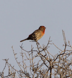
The House Finch was interesting:  I don’t know the bird well and thought it was some bunting.  The male is just spectacular, as is the singing. 

House Finch

Big Bend has hundreds of birds on the list although many are migration spottings or later in the year.  I’ve got a few on my list though — so Penny and I will be out and about scanning.  I guess I can’t count stuff across the river – that’s Mexico.

Big Bend Adventures

As Big Bend State Park visitors know, it’s about 70 miles of desolation from Marathon down to the park headquarters, and then another 20 miles of desert to the Rio Grande Village campground. But what amazing vistas as you head south — just breathtaking. Photos don’t do the landscape justice. Geological features – incredible formations – give a real sense of the millions of years of history that precedes us.

Yesterday’s high was 96 degrees and we arrived, hot and dusty, and set up. There’s no air conditioning (no power or water) but we were doing fine — until I learned that I had set up on a site already reserved by someone else. So, it was stow things, hitch up once again, and move about 100 yards up the road to another site. I wasn’t a happy camper and Mary was overheated from the heat and dryness. Great start — Big Bend.

Once things cooled down, it was a lovely evening. It went down to 44 this morning and we ran the heater for a bit while having morning coffee. I found out that the little store here has WiFi (you can forget AT&T coverage for cell phones) so we could get email and post stuff. Still, with no electricity, battery usage for the computers needs to be monitored as well.

I took a little hike this morning on a short trail and saw a few birds, the Rio Grande, some cool rock formations, the Rio Grande, and Mexico. Above is an early morning shot of the campground and the scenery.

They warned us about wildlife here — particularly coyotes. Well, as we were leaving this morning to do some sightseeing in the truck, what should wander right in front of us, in the middle of the campground, by Mr. (or Ms.) Coyote. Took the picture through the windshield.


We drove up to the Chisos Basin which is just about impossible to describe. It’s high elevation for down here and has some spectacular mountains and vistas. I’ll get some shots next visit — we just took a “I’ve Been There” shot at the visitor center.

We have hung out reading this afternoon underneath the trailer’s awning. It’s about 88 degrees but there’s a nice breeze. I had Penny’s leash anchored by my chair leg. I left to fix a couple of seltzer drinks and from inside the trailer heard a bark, a yell from Mary, and a upsetting of the lawn chair. Mr. Coyote (or a sibling) had just crossed our road about 25 feet away and Penny was in attack mode. Fortunately, the leash got caught — or she got smart — and I grabbed her and all was well again — once Mary’s heart rate settled down.

This is a tough place from noon to five or so — you can see why siestas so popular in the Southwest. After May, things essentially close down here due to the extreme temperatures. However, we saw scenery today that just blows you away. Now, to keep the coyotes, mountain lions, and javelinas where they belong.

P.S. On guidebook we have, in talking how park animals have gotten too used to human foods, said that the crinkling of a potato chip bag opening can draw javelinas. I knew junk food was not good for you.

Seminole Canyon State Park


Less than an hour away from Amistad National Rec Area, where we stayed two days, is Seminole Canyon where we have enjoyed a couple more days enroute to Big Bend. Seminole — I thought they were Florida tribe. Well, they were until they were moved west, along with the African-Americans who had assimilated into their ranks, in a “Trail of Tears” forced resettlement. The U.S. Army formed a unit of Seminole-Negro Indian Scouts who protected this area from marauding bands of Apaches and Comanches. Four scouts earned the Medal of Honor. Thus the park name.

There are some nice bike/hiking trails out to the Rio Grande which Penny and I have taken advantage of. It’s rocky or dusty but pretty flat and dry. I carry water and we stop every so often. They cloudiness of the last couple of days helped a great deal. What amazing vistas along the canyon — well worth the ride. Penny sleeps well at night.
Today, Mary and I each took a tour (hers was in the morning and mine in the afternoon) of the prehistoric rock art — rock painting called pictographs. This two-mile, guided, walking tour descends into a limestone canyon where we saw Lower Pecos River Style pictographs. We went up to the Fate Bell Rockshelter (named for a former owner) which contains pictographs which are 4,000 years old — among the oldest, most colorful, complex and distinctive ancient paintings in all of the Americas. It was educational and thought-provoking.

Of course, my small tour group included two instructor pilots from nearby Laughlin AFB who were camping with their young sons. They were both former F-15 pilots and humored a former Naval Aviator as we talked about their T-6 trainers, their students, and other aviation stuff on the way back. Nice guys — and their sons running along ahead up the steep staircase reminding me of our two guys years ago.

We had snacks this evening looking west as the sun was setting with Lark Buntings and Black-throated Sparrows hopping around the picnic area. A Sage Thrasher commenced a wonderful series of songs and calls. It was a nice Saturday evening in West Texas.

Are We There Yet?

Are We There Yet?

Today was a “round them up, move them out” travel day through hot, dusty Southwest Texas.  If I never see another thorn shrub or natural gas pipeline, it won’t break my heart.  Of course, the speed limit is often 75 mph but I keep below 70 while hauling the trailer.

Laredo was awful — traffic lights, depressing fast food joints and rundown businesses — and Eagle Pass and Del Rio were not a lot better.  It’s interesting — you can look up ahead near the border and see this massive Mexican Flag just across the border.  We had at least two situations where you needed to turn right to stay in the U.S. and not head to the International Bridge.  

Of course, have two American immigration guys shot yesterday adds to the “stay out of Mexico” mindset that most of us have.

Just west of Laredo were these amazing highway overpasses, all stucco-colored and lovely looking.  I was trying to figure out which Congressman/Senator brought that pork home when we came to the Laredo Welcome Center.  It makes the Williston and Brattleboro sites in Vermont look like poor cousins — to say it was ornate is an understatement.  Here’s a picture of Mary in front of it.

I got to watch a Border Patrol stop at the site.  They had a pickup hauling a trailer stopped and were apparently also using it as a training because four or five extra guys were there.  The interesting thing was the Xray truck — a big van which slowly drove closely past one side of the stopped trailer and then past the other side.  Obviously, they have gear that can look through metal side of vans.  I think they let the guys move on after going through the items in the trailer.

Shortly thereafter, we went through a Border Patrol stop.  Of course, Penny saw the drug dog, a Doberman, and started to go nuts while I reached back for her and her collar came off — all while trying to talk sanely to the young guy asking me questions.  We’re pretty white bread tourists — he just waved me on.

We are at Amistad, a national recreation area on the shore of Lake Amistad which is formed by the dammed Rio Grande.  No one here besides a host camper and one other family.  We have a site overlooking the water and while there’s a little noise from the highway not too far away, it’s a nice location.  We are going to a “Cowboy Coffee” in the morning where they make coffee the old way, over a campfire — and the park superintendent is going to talk some about border issues.

Are We There Yet?

Are We There Yet?

Today was a “round them up, move them out” travel day through hot, dusty Southwest Texas.  If I never see another thorn shrub or natural gas pipeline, it won’t break my heart.  Of course, the speed limit is often 75 mph but I keep below 70 while hauling the trailer.

Laredo was awful — traffic lights, depressing fast food joints and rundown businesses — and Eagle Pass and Del Rio were not a lot better.  It’s interesting — you can look up ahead near the border and see this massive Mexican Flag just across the border.  We had at least two situations where you needed to turn right to stay in the U.S. and not head to the International Bridge.  

Of course, have two American immigration guys shot yesterday adds to the “stay out of Mexico” mindset that most of us have.

Just west of Laredo were these amazing highway overpasses, all stucco-colored and lovely looking.  I was trying to figure out which Congressman/Senator brought that pork home when we came to the Laredo Welcome Center.  It makes the Williston and Brattleboro sites in Vermont look like poor cousins — to say it was ornate is an understatement.  Here’s a picture of Mary in front of it.

I got to watch a Border Patrol stop at the site.  They had a pickup hauling a trailer stopped and were apparently also using it as a training because four or five extra guys were there.  The interesting thing was the Xray truck — a big van which slowly drove closely past one side of the stopped trailer and then past the other side.  Obviously, they have gear that can look through metal side of vans.  I think they let the guys move on after going through the items in the trailer.

Shortly thereafter, we went through a Border Patrol stop.  Of course, Penny saw the drug dog, a Doberman, and started to go nuts while I reached back for her and her collar came off — all while trying to talk sanely to the young guy asking me questions.  We’re pretty white bread tourists — he just waved me on.

We are at Amistad, a national recreation area on the shore of Lake Amistad which is formed by the dammed Rio Grande.  No one here besides a host camper and one other family.  We have a site overlooking the water and while there’s a little noise from the highway not too far away, it’s a nice location.  We are going to a “Cowboy Coffee” in the morning where they make coffee the old way, over a campfire — and the park superintendent is going to talk some about border issues.

Hummers


Buff-bellied Hummingbird at Roma Bluffs

One of the nice aspects of birding in South Texas in winter is the chance to see hummingbirds.  Some overwinter and others just show up at feeders.  The Anna’s that we saw at Goose Island was of the latter category.  So was an Allen’s that we missed in Bentson State Park the other day.

Saturday we went down to the Roma Bluffs World Birding Center site — one of six such sights in the Lower Valley of Texas.  Roma get some hummers including this Buff-Bellied Hummingbird – one of the species that has been there all winter.  They have a few of these and they are relatively tame — allowing visitors to get rather close.  Mary noted that given their irridescent green back, they are misnamed buff-belly.

We missed a Black-Chinned Hummingbird that supposedly shows up but hope to catch up with one further west.  Coming from a state which usually just gets Ruby-throated hummers, it’s quite something to have a chance to see so many varieties.  And in the months ahead, after we’ve left, there will be dozens of varieties.

As an aviator, as a novice birder, just as an observer – they are just amazing creatures to watch and appreciate.  Feisty, beautiful, spectacular, mesmerizing.